Cartes montrées par VAR Kimhong :
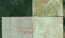
1 – Les cartes sont au format 1/50.000 ème
2 – Ces cartes ont été copiées (NON CERTIFIEES) de celles au format 1/100 000 ème puis
3 – Elles ont été redessinées par un “JOINT WORKING GROUP” suite au dictat frontalier du Vietnam en 2005.
Donc ces Cartes sont ANTI-CONSTITUTIONNELLES vu l’article 2 de la CONSTITUTION qui stipule :
“L’intégrité territoriale du royaume du Cambodge est absolument inviolable dans ses frontières délimitées sur les cartes à l’échelle 1/100.000 établies entre les années 1933-1953 et internationalement reconnues entre les années 1963-1969″
Le ROI du Cambodge devra réagir un JOUR ou l’AUTRE vu l’article 8 de la constitution :
“Le Roi est le garant de l’indépendance nationale, de la souveraineté et de l’intégrité territoriale du Royaume du Cambodge. Il est le garant du respect des droits et libertés des citoyens et du respect des traités intenationaux.“
លោក វ៉ា គឹមហុង បដិសេធមិនទៅពិនិត្យព្រំដែនតាមការបបួលរបស់តំណាងរាស្ត្របក្សប្រឆាំង
លោក វ៉ា គឹមហុង បដិសេធមិនទៅមើលបង្គោលព្រំដែនតាមបក្សប្រឆាំងស្នើសុំ

លោក វ៉ា គឹមហុង មិនផ្តល់សម្ភាសន៍ក្រោយបញ្ចប់កិច្ចប្រជុំជាមួយភាគីវៀតណាមនៅព្រឹកនេះ
តំណាងរាស្ត្របក្សសង្គ្រោះជាតិអញ្ជើញលោក វ៉ា គឹមហុង ទៅពិនិត្យព្រំដែនរួមគ្នា
ពលរដ្ឋខ្មែរនៅភ្នំពេញបារម្ភអំពីផែនទីបោះពុម្ពដោយវៀតណាម
Putting border issue on the map
…
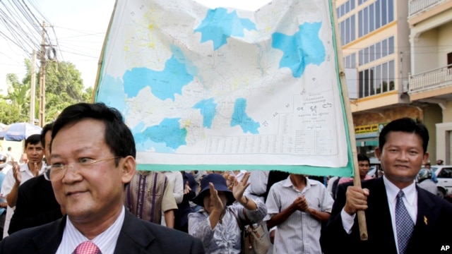
VAR Kimhong
told journalists and opposition lawmakers present that the maps, drawn to a 1/50,000 scale, were copied from the constitutionally mandated 1/100,000 scale maps – produced by French colonial authorities and submitted to the United Nations by late King Norodom Sihanouk in 1964.
He said they were jointly developed over the course of a month in Vietnam following the 2005 border agreement, which the opposition insists ceded territory.
Vietnam provided a “white map” without a border, and a joint working group drew the boundary, which was then approved and signed by the two border committee presidents, Kimhong said.
“We have respected the constitution fully,” he added.
…
SAM Rainsy
said the “bits and pieces” presented by Kimhong “didn’t prove anything” when it came to whether the delineation was being correctly executed, while the map’s Vietnamese origin was concerning.
“The question is, did they actually use those maps to delineate the border,” he said.
“Those maps were produced in Vietnam, so it is very suspicious; when you have a border conflict with a country how could you rely on a map produced by that country? That’s irresponsible.”
Rainsy said the CNRP will propose a bipartisan committee, involving both ruling and opposition lawmakers and independent cartographers, to investigate whether border markers were correctly placed using GPS.
តំណាងរាស្ត្របក្សប្រឆាំងនៅតែថារដ្ឋាភិបាលមិនប្រើផែនទីតម្កល់នៅអង្គការសហប្រជាជាតិ
Government Denies Using Wrong Border Map

ការជជែកគ្នាពីខ្សែព្រំដែនកម្ពុជា-វៀតណាមត្រង់ចំណុចព្រែកជីកវិញតេន…
លោកវ៉ាគឹមហុងបង្ហាញផែនទីនៅតំបន់តន់ហន់ដល់តំណាងរាស្ត្របក្សប្រឆាំង
តំណាងរាស្ត្របក្សប្រឆាំងនៅតែថារដ្ឋាភិបាលមិនប្រើផែនទីតម្កល់នៅអង្គការសហប្រជាជាតិ
លោក វ៉ា គឹមហុង អះអាងថាផែនទីបោះបង្គោលព្រំដែនជាមួយវៀតណាមចម្លងមកពីអង្គការសហប្រជាជាតិ
បក្សប្រឆាំងមិនទទួលស្គាល់ផែនទីបោះបង្គោលជាមួយវៀតណាមដែលបង្ហាញដោយរដ្ឋាភិបាល